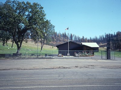
Big Bend, California
Big Bend sits along a dramatic curve of the Pit River in Shasta County at 1,720 feet elevation, occupying territory historically significant to the Madesi tribe.
The location sits less than 40 feet from the roadway in a heavily timbered landscape receiving 50 inches of annual precipitation and 64 inches of snow. The community of 79 residents has maintained settlement along this major river bend, where the Pit River makes a pronounced directional change through steep canyon terrain.
The roadside location makes Big Bend easily accessible via Highway 299. While no thermal spring temperature is recorded for this entry, the location appears in thermal datasets due to historical geothermal activity. Winter travel requires caution on mountain roads. Camp 4 Group Campground, 24.7 kilometers away, offers primitive group camping.
Big Bend marks an indigenous landmark named for a major course change of the Pit River. The location represents both geographic and cultural significance to the Madesi people, with the census-designated place preserving the community's connection to this river landscape over multiple centuries.
Some links are affiliate links. We may earn a commission at no extra cost to you.
Overview This group site is nestled in the Shasta-Trinity National Forest on the Upper McCloud River, popular for its three stunning waterfalls.Camp 4 is typically open from mid-spring through mid-fall, offering primitive accommodations near a variety of recreational activities and magnificent scenery.Note: This is not Camp 4 in Yosemite National Park. Learn more about the Camp 4 daily lottery in Yosemite National Park. Recreation During the late spring, summer and early fall, the McCloud Riv...
Big Bend, California is road-accessible, so you can bring more gear.


As an Amazon Associate, we earn from qualifying purchases.
Springs Near Big Bend, California
Hike 6 waterfalls near Big Bend, California

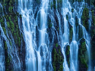
Looking for more outdoor adventures? Explore waterfall hikes near Big Bend, California, California.