Muir Springs
Muir Springs flows at a modest 68°F (20°C) in Mendocino County's coastal mountains, sitting 11 degrees above the ambient temperature in a landscape where redwood forests transition to oak woodland near Lake Mendocino.
The spring emerges within classic North Coast Range terrain—dense mixed forest with redwoods, Douglas fir, and tanoak. The water flows cool and clear through a short walk (156 meters) from Canyon Road. Visitors experience a landscape of dappled shade, understory ferns, and the sound of flowing water, characteristic of Mendocino's inland valleys.
The spring requires only a short walk from Canyon Road, making it accessible year-round. Best visited in cooler months (November–April) when forest trails drain well and temperatures remain mild. Lake Mendocino day-use areas lie 24 kilometers away; no on-site facilities exist at the spring itself.
Muir Springs derives its name from John Muir's influence on California's conservation movement, though specific geological formation details remain limited. The modest temperature elevation suggests relatively shallow geothermal circulation in this coastal range province.
Some links are affiliate links. We may earn a commission at no extra cost to you.
Overview Pomo Day-Use Area is situated on Lake Mendocino in California's Mendocino Range, where the redwood forests meet California wine country. The lake is formed by the Coyote Dam on the Russian River. A wide variety of recreational opportunities are available, including boating, swimming, water skiing, fishing, hiking and horseback riding.Recreation The 1,822-acre lake provides abundant boating, swimming and water skiing opportunities. There is a designated swim beach in the Pomo Recreat...
Muir Springs is road-accessible, so you can bring more gear.


As an Amazon Associate, we earn from qualifying purchases.
Springs Near Muir Springs
More Springs Around 68°F
Hike 1 waterfall near Muir Springs
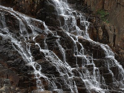
Looking for more outdoor adventures? Explore waterfall hikes near Muir Springs, California.