River Group
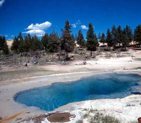
River Group in Yellowstone's Lower Geyser Basin produces waters at 205 degrees Fahrenheit—169 degrees above the 36-degree ambient—at 7,192 feet elevation. The springs sit 466 meters from roads, accessible via a short walk through thermal terrain under Protection Status 1 management. At 205 degrees, this River Group ranks among Yellowstone's hottest springs, exceeding the boiling point at sea level and approaching it at this elevation.
The springs discharge in classic hydrothermal landscape at moderate elevation, surrounded by siliceous sinter deposits, algal mats, and thermal runoff channels typical of Yellowstone's geyser basins. The setting receives 28 inches of annual precipitation with 141 inches of snowfall, creating snow-dominated conditions from November through May. The springs lie within the Lower Geyser Basin complex where numerous thermal features cluster near the Firehole River drainage. Wikipedia notes Azure Spring nearby operates at 174 degrees and sits close to Pocket Basin Geyser, indicating a zone of intense geothermal activity.
Visit from June through September for clearest access, though May and October are possible if weather permits. Park entrance fees apply. The 466-meter walk from parking follows thermal terrain where staying on trails is mandatory—ground instability and extreme temperatures pose serious hazards. The 205-degree water causes instant severe burns on contact. Big Springs Group Area in Idaho lies 34 kilometers away with reservable camping. Bring layers for variable mountain weather and bear spray for safety. Combine with Fountain Paint Pot and other Lower Geyser Basin features.
The name "River Group" references proximity to the Firehole River, which drains much of Yellowstone's thermal basin runoff. Historical documentation dates to systematic geothermal surveys preceding the 1980 NOAA publication, with early park visitors and scientists observing the feature as Lower Geyser Basin became accessible in the early 20th century. National Park Service maintains the springs in natural state without development, relying on visitor education and designated trails to prevent dangerous approaches to extreme-temperature features.
Some links are affiliate links. We may earn a commission at no extra cost to you.
Overview Big Springs Group Area is located 22 miles south of West Yellowstone, Montana in beautiful Island Park, Idaho at an approximate elevation of 6,300 feet. Visitors love Island Park for its world-class fishing and outstanding scenery and wildlife viewing opportunities.Recreation Big Springs is the headwaters of Henry's Fork and is one of the largest springs in the country. Henry's Fork is considered one of the best fly-fishing streams in the nation. Fishermen cast for rainbow and brook...
River Group sits at 7,192 feet above sea level, way above the mile-high mark. You may not feel the altitude strongly, but hot water still dehydrates you faster at elevation. UV is about 29% stronger than at sea level, so bring sunscreen and drink more water than you normally would.


As an Amazon Associate, we earn from qualifying purchases.
River Group is road-accessible, so you can bring more gear. The water is dangerously hot — bring water shoes and test pools carefully. Cold air temperatures make a changing robe or warm layers essential.


As an Amazon Associate, we earn from qualifying purchases.
Springs Near River Group
More Springs Around 205°F
Hike 6 waterfalls near River Group
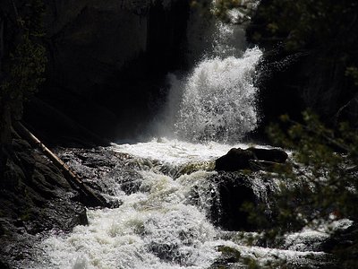
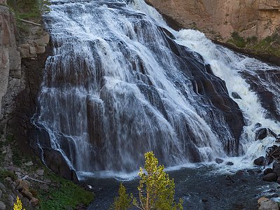
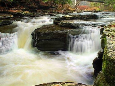
Looking for more outdoor adventures? Explore waterfall hikes near River Group, Wyoming.