Buffalo Bill Reservoir Springs
Buffalo Bill Reservoir Springs flows at 5,390 feet elevation along the southern margins of Buffalo Bill Reservoir, classified as warm without specific temperature measurements. Located 407 meters from the nearest road, this short-walk spring emerges within state park boundaries managed by the Bureau of Reclamation under protection status permitting extractive and recreational use. The spring discharges in terrain receiving 19.1 inches of annual precipitation and 63.5 inches of snow with annual temperatures averaging 42.1°F.
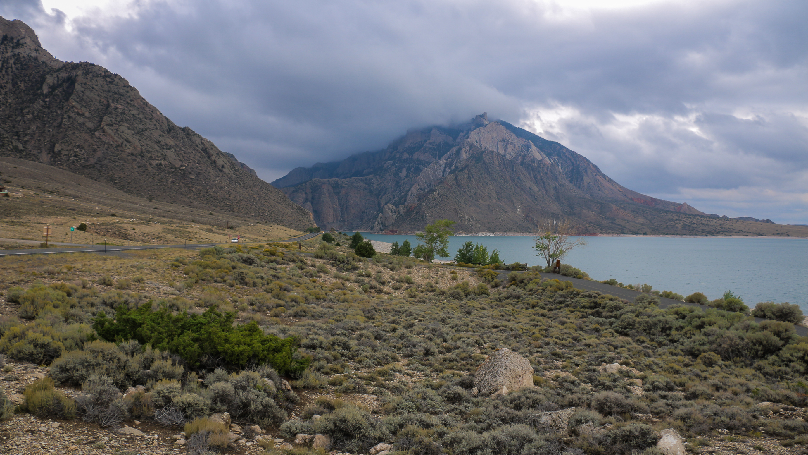
The spring flows at 5,390 feet along the reservoir's southern shoreline, where the impounded Shoshone River creates a narrow reservoir extending westward through steep canyon topography. Sedimentary rock formations of Paleozoic and Mesozoic age form the canyon walls, with sagebrush-grassland communities dominating the semi-arid slopes. Cottonwood and willow grow along the original river channel now submerged beneath reservoir waters. The surrounding landscape shows evidence of uplift and erosion associated with the Absaroka volcanic field. Seasonal water level fluctuations expose mudflats and altered shoreline zones.
Access the area from April through October when moderate weather permits shoreline exploration. The 407-meter walk from roadways requires navigation through variable terrain affected by reservoir operations and seasonal water levels. Winter temperatures averaging 42°F with 63.5 inches of snow create cold but manageable conditions. The spring's warm classification suggests limited bathing potential. Big Game Campground 30.6 kilometers west provides camping access along Buffalo Bill Scenic Byway. Combine with reservoir recreation and drives toward Yellowstone's east entrance 23 miles west.
This spring shares nomenclature with other thermal features along Buffalo Bill Reservoir, all named for the legendary William F. Cody who established the town of Cody in the 1890s to capitalize on tourism, irrigation development, and access to Yellowstone National Park. Dam construction from 1905-1910 transformed the natural Shoshone River corridor into a reservoir storage facility. Indigenous peoples including Crow, Shoshone, and others traveled the Shoshone River corridor for thousands of years before Euro-American settlement. Current management focuses on irrigation storage and recreation rather than thermal resource preservation.
Some links are affiliate links. We may earn a commission at no extra cost to you.
Overview Big Game Campground is located along the Buffalo Bill Scenic Byway about 29 miles west of Cody, in northwestern Wyoming. It is 23 miles east of the east entrance to Yellowstone National Park. The surrounding area offers many outdoor recreational opportunities, including fishing, hiking and viewing local wildlife.Recreation Great opportunities for hiking, fishing, scenic driving and wildlife viewing are available around the campground. The North Fork of the Shoshone River is a popular...
Buffalo Bill Reservoir Springs sits at 5,390 feet above sea level, way above the mile-high mark. You may not feel the altitude strongly, but hot water still dehydrates you faster at elevation. UV is about 22% stronger than at sea level, so bring sunscreen and drink more water than you normally would.


As an Amazon Associate, we earn from qualifying purchases.
Buffalo Bill Reservoir Springs is road-accessible, so you can bring more gear. Cold air temperatures make a changing robe or warm layers essential.


As an Amazon Associate, we earn from qualifying purchases.
Springs Near Buffalo Bill Reservoir Springs
Hike 6 waterfalls near Buffalo Bill Reservoir Springs
Looking for more outdoor adventures? Explore waterfall hikes near Buffalo Bill Reservoir Springs, Wyoming.